Nor'easter Slams East Coast: Flooding, 74 MPH Winds, One Dead
feeds · September 26, 2026
Key takeaways
- A powerful nor'easter brought 74 mph wind gusts, 16-foot waves, and record-level tides to NJ, NY, and southern New England.
- One person died in Brooklyn after being struck by a falling tree; both New York and New Jersey declared states of emergency.
- Coastal flooding hit near-record levels, with Freeport, Long Island seeing its highest tide in over two years.
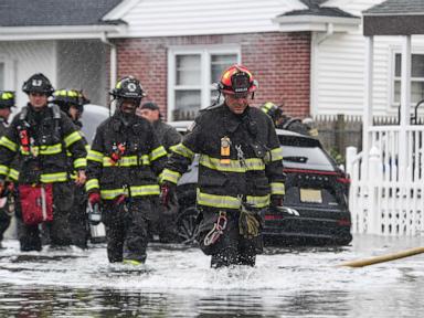
What Happened An early-season nor'easter tore through the East Coast this weekend, dumping torrential rain and whipping up destructive winds across New Jersey and New York. Both states are under a state of emergency as the storm combined with high tide to flood streets, topple trees, and send waves crashing over the Jersey Shore.
The numbers tell the story: a weather station in Surf City, New Jersey clocked a wind gust of 74 mph, with multiple stations along the shore reporting gusts over 60 mph. Buoys off the coast measured waves of 16 feet or higher. In Freeport, Long Island, high tide hit 7.8 feet — the highest reading in over two years. Ocean County, New Jersey saw its third-highest tide on record at 5.7 feet.
The storm turned deadly in Brooklyn, where a 56-year-old New York City Housing Authority employee was killed by a falling tree while walking through a parking lot. Video and photos from across the region show flooded streets in Atlantic City, kayakers paddling down submerged neighborhoods in Beach Haven West, and waves pounding the coast in Scituate, Massachusetts.
Why This Storm Hit So Hard Nor'easters draw their punch from the collision of cold air moving south and warm, moisture-rich air pulled up from the Atlantic. When that timing lines up with high tide — as it did this weekend — coastal flooding gets amplified fast. That's exactly what happened along the Jersey Shore and Long Island, where storm surge stacked on top of already-elevated tides to push water into streets and low-lying neighborhoods.
The early-season timing is notable too. Nor'easters typically strengthen through late fall and winter, so a storm producing 74 mph gusts and near-record tides this early is a signal that coastal communities should stay alert for more extreme weather swings this season.
What Happens Next New York Gov. Kathy Hochul has already declared a state of emergency and mobilized state resources as officials assess downed trees, flooded roadways, and storm damage. Cleanup crews are expected to spend the coming days clearing debris and pumping out flooded areas, while residents in low-lying coastal zones are being urged to avoid unnecessary travel until floodwaters recede.
If you're in the affected region, check local emergency alerts before heading out, avoid flooded roads (it takes surprisingly little water to stall or float a car), and steer clear of areas with downed trees or power lines. Coastal residents should also keep an eye on tide charts over the next few days, since additional high-tide flooding is possible even after the storm itself clears out.
Why it matters
If you live along the Northeast coast, this storm is a preview of what an active fall/winter storm season could bring. Knowing the flood and wind risks now helps you prepare — from checking tide charts to having an emergency plan ready before the next system rolls in.
Want deals on what you love?
Val finds local offers matched to your interests — free to start.
Meet Val